Course Overview
To visualise this, load the map on the GAIA site
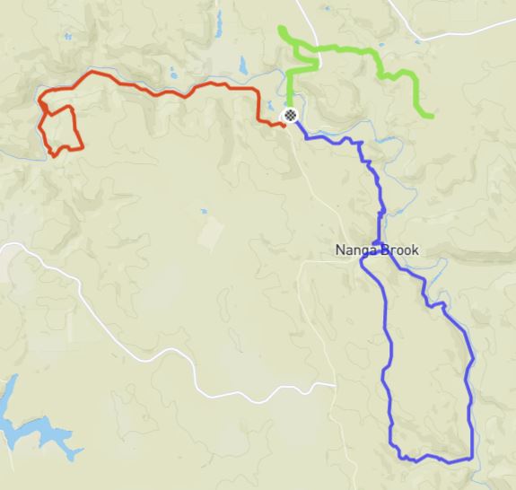
The race starts and finishes from the event HQ at Nanga Bush Camp, with three out and back legs.
- Leg 1 (red) is 25 km with 1225m elevation gain (aid station at the half-way point)
- Leg 2 (blue) is 33 km with 657m elevation gain (aid station at Nanga Brook Campground, approx 7.5k & 25k into the leg)
- Leg 3 (green) is 22 km with 654m elevation gain (no aid station)
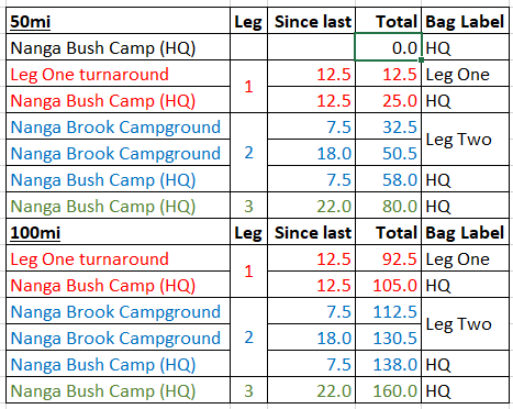
The 100mi event covers each leg twice, as detailed below:
Drop bags
Runners may have two drop bags, labelled “Leg One” and “Nanga Brook Campground” (or “Leg Two”). You can also leave a drop bag / clothing etc at the Race HQ and Nanga Bush Camp, as runners pass through this when transitioning between legs 1, 2 and 3.
Support Crew
Support crew can assist runners at Nanga Bush Camp and Nanga Brook Campground. There is no access to Legs 1 and 3 for support crew. No assistance should be provided to runners outside of the official aid station locations – penalty is DQ.
GPX files
You can load the course onto your devices by downloading the GPX file (above) and importing per your watch manual
On an iPhone or Android Phone, you can track the course (offline) using a number of different apps. GAIA GPS is probably the easiest:
GAIA GPS:
- Create an account at https://www.gaiagps.com (free version is fine)
- Click on this link to view the WTF 50mi course on GAIA
- You’ll see just above the map an option to “+ Add to my tracks”; click on this
- At the top-right of your screen, click on the drop down showing your username and select Tracks
- Confirm that you can see the WTF 50mi 2021 course listed, and on the right under “Sync” it should say on
- Now install the GAIA GPS app onto your smartphone, and login with the same username/password as used on the GAIA website
- At the bottom of the screen, select “Saved” ; after a few moments it should load the WTF50mi map.
- Now when you click on the Map at bottom of screen, zoom out on the map until Dwellingup is shown, and you should see the WTF course highlighted.
- When on the course, you current location will be shown on the map, and you can zoom-in, zoom-out to see your location in relation to the course in more detail.